IMPORTANT UPDATE :: Workshop Cancelled (June 25, 2015)
Due to a low number of submissions and due to personal reasons, we have finally decided to cancel the workshop. We are very sorry for the inconvenience!
Thanks for your interest,
Francis and Johannes
Call for participation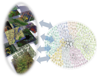
Data intense spatial applications can be supported
using a variety of open data sources available on the Internet. Due to
the fact that more finely granular open data sources from various
providers become available for all possible uses, and the combinations
therefore are unlimited, developing intelligent solutions using
semantics is an important activity for scientists and practitioners.
Guiding the linking of data sources makes cross cutting (aggregation,
integration) and novel analysis of data sources possible and makes it
possible to develop new insights.
The aggregation or integration of different data
sources involves geospatial or attribute commonalities shared by at
least two datasets. In order to establish accurate links between
datasets the semantics of the data sets is of great importance. When
working with spatial phenomena, the linkage of different datasets based
on location helps to make additional links. In addition, other
non-spatial datasets may be “georeferenced” with respect to their
implicit location information. Even if 80% of all data is spatial, an
enormous effort is required to work with this data. Linked open data
approaches offer concepts and practices to help streamline development
work and produce efficient processes with robust results.
For these reasons, this workshop aims to facilitate
new ideas and highlight best practice work using linked open data to
aggregate and integrate spatial data and non-spatial data regardless of
the explicit or implicit expression of semantics. Connections between
Information Integration and Semantic Web Technology are key elements of
the workshop. Of importance in this respect are considerations of ways
to identify entities/places in different datasets that utilize different
universes of discourse or viewpoints.
The workshop is open to all and will take place in conjunction with GI_Forum 2015 (www.gi-forum.org) on July 07, 2015, in Salzburg, Austria. We are soliciting presentations (short, long, or poster formats) for the workshop now. The deadline is 15 May 2015 01 June 2015.
You can download the Call for Papers as PDF here.
Workshop Objectives and Topics
The objectives of the L(O)D workshop are to bring
scientists and practitioners together and to share developments, ideas
and best practice models involving Linked (Open) Data – especially work
related to geospatial information integration. Besides the core subject
of LOD, presentations on topics connected to Linked Data like Semantic
Web Technology or Information Integration are of vital interest for this
workshop. Emphasis will be given to short (5 minutes) and long (20
minutes) oral presentations in and interactive workshop discussions
format in a lively format orientated to learning and networking. Space
will also be provided for posters including time for informal
presentations during the workshop. Participants can expect a vibrant
exchange of ideas and creation of opportunities for future
collaborations.
Topics for the Workshop include, but are not limited to
-
Best practice examples, where spatial inforamtion and other data souirces are integrated;
-
Identifying and presenting layers of informatoin about a specific location;
-
Technology landscape of semantic web technologies for spatial data/phenomena - problems encountered, solutions found or missing;
-
Mappings/links between the SDI models, registers/registries and semantic ontologies;
-
Information Integration of various data sources;
-
Extracting and defining semantics of spatial open data;
Contribution and Participation
The organizerst of the workshop invite you to submit contributions to the workshop, offering the following formats:
- Oral presentations: to be considered for a short or long oral presentation, submit an abstract for review (max. 500 words).
- Poster: the presentation of a poster during the workshop requires submitting an abstract for review (max. 500 words).
Please submit your abstract using the Easychair system, which is available here: https://easychair.org/conferences/?conf=lodgi-forum-2015
The contributions will be reviewed by the scientific committee and the organizing committee and selected according to the review. The workshop is fully integrated in the GI_Forum 2015 conference. Thus, there is no separate workshop registration fee besides the regular registration fee for GI_Forum 2015. Everyone is cordially invited to attend the workshop at GI_Forum 2015!
Agenda for the Workshop
The programme for the workshop will be found here. If you have any suggestions - feel free to drop us (Francis Harvey or Johannes Scholz) a line!
Important Dates
| What? | Date |
|---|---|
| Submission of Abstracts for Oral Presentation | 15-05-2015 01-06-2015 |
| Submission of Abstracts for Poster Presentation | 15-05-2015 01-06-2015 |
| Notification of acceptance | 15-06-2015 |
| Workshop | 07-07-2015 |
Scientific and Organizing Committee
| Scientific Committee | Organizing Committee |
|---|---|
| Andreas Blumauer (Semantic Web Company) | Francis Harvey (Leibnitz Institute for Regional Geography/University of Leipzig) |
| Johann Höchtl (Danube University Krems) | Johannes Scholz (Graz University of Technology, Institute of Geodesy, Research Group Geoinformation) |
| Adam Iwaniak (Wroclaw University of Environmental and Life Sciences) | |
| Krzysztof Janowicz (University of California Santa Barbara) | |
| Simon Scheider (ETH Zürich) | |
| Dalia Varanka (U.S. Geological Survey) | |
| Nancy Wiegand (University of Wisconsin - Madison) |
Further Information
For further information please visit the workshop webpage (http://linkeddata.johannesscholz.net) or contact the organizers directly:
- Johannes Scholz (johannes.scholz (_at_) tugraz.at )
- Francis Harvey (f_harvey (_at_) ifl-leipzig.de)